Why Drone Scouting?
Why Drone Scouting?


What Is Drone Scouting?
Drone scouting uses unmanned aerial vehicles, like advanced thermal or multispectral drones, to gather real-time wildlife and habitat data. At ScoutFlight Hunting Assessments, we leverage this technology to provide accurate, insightful assessments for landowners and hunters throughout Michigan, Indiana, and Ohio. Whether you’re curious about deer population densities or looking to improve your habitat, drone scouting offers a modern, non-intrusive way to get the data you need.
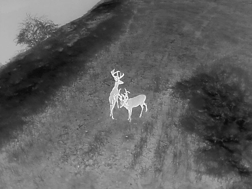
How can you be sure that a thermal drone survey is actually the most accurate way to count deer, especially in thick cover or challenging terrain where traditional methods might still be effective?
As a landowner or prospective buyer, having a clear understanding of the wildlife on a property is essential. Conducting a thermal drone survey with ScoutFlight Hunting Assessments gives you the most accurate count of your deer population, providing the critical data needed to optimize your hunting strategies, habitat improvements, and overall wildlife management. By evaluating buck-to-doe ratios and assessing buck quality, you move beyond guesswork and gain the insights necessary to make well-informed decisions for the seasons ahead.
Why Drone Scouting vs. Traditional Methods
Efficiency and Accuracy
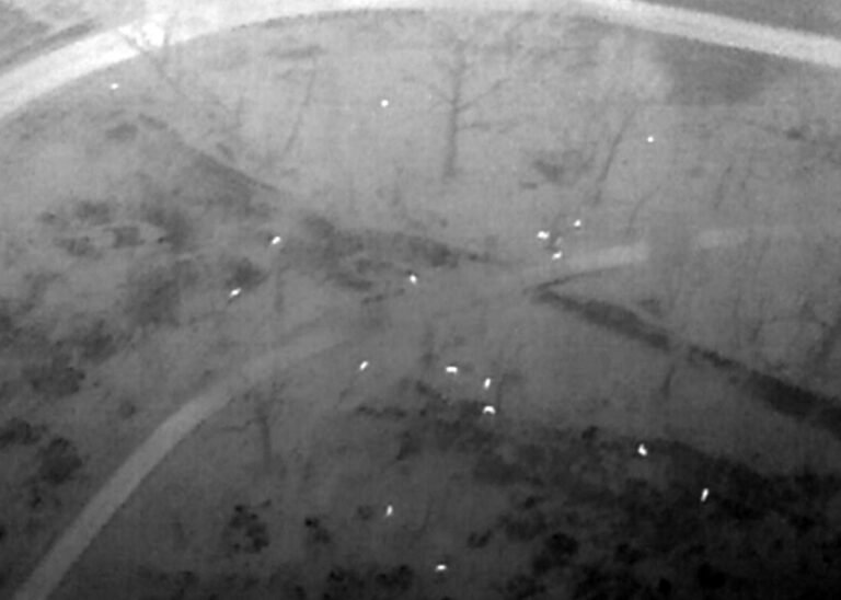
Thermal imaging can detect animals even in thick cover or challenging terrain.
Drones capture comprehensive aerial views, reducing the chance of missed observations common in ground-based counts.
Reduced Stress on Wildlife
By operating above the habitat, drones minimize direct disturbance compared to foot surveys or vehicle-based scouting.
Surveys typically happen outside of the hunting season, aligning with Michigan regulations and ensuring ethical wildlife observation.
Data Visualization
High-resolution photos and video allow you to see exactly what’s on your land.
Geographic mapping tools display buck-to-doe ratios, deer movement corridors, and population hot spots.
Key Benefits for Landowners and Hunters
Informed Habitat Management
Get actionable insights on where to place food plots or bedding areas.
Make smarter decisions on culling and herd management.
Season Planning
Scout out buck quality and deer densities before the season opens.
Know your property’s strengths and weaknesses to optimize your hunt.
Property Valuation & Sales
Prospective buyers love hard data. Accurate deer counts and wildlife assessments can raise property appeal and confirm its true potential.
Sellers can showcase proof of healthy herds and robust habitats.


ScoutFlight: Because the Way You See Your Land Makes All the Difference
ScoutFlight: Because the Way You See Your Land Makes All the Difference
ScoutFlight Hunting Assessments uses cutting-edge drone technology to provide landowners, hunters, and real estate professionals with accurate, non-invasive wildlife and land data. Our thermal imaging and high-resolution aerial surveys deliver detailed deer population counts, movement insights, and habitat assessments, helping clients make informed hunting, conservation, and property management decisions. With affordable pricing, advanced drone capabilities, and future expansion into aerial disease prevention and habitat restoration, ScoutFlight is revolutionizing how serious hunters and land managers understand their land.


Frequently Asked Questions (FAQ)
Are drones legal for hunting in Michigan?
Under Michigan Compiled Laws, Chapter 324. Natural Resources and Environmental Protection § 324.40111c (2), an individual cannot “take game or fish using an unmanned vehicle or unmanned device that uses aerodynamic forces to achieve flight.” Therefore, ScoutFlight conducts surveys outside the active hunting season, ensuring full legal compliance and ethical use.
Do you have insurance for drone operations?
Yes, we carry comprehensive liability insurance covering our drone flights. This protects both our clients and us in the unlikely event of any incident.
What about pricing?
We do list standard prices. Contact us for quotes, and we’ll work with you to determine a fair rate based on acreage, terrain, and the survey scope.
Can you guarantee an exact deer count?
While drone technology offers high accuracy, factors like dense cover or extreme weather can influence results. Our approach minimizes these challenges, providing some of the most reliable data you can get without physically tagging each animal.
How quickly will I receive my results?
We typically deliver comprehensive reports within a few days of the flight, including imagery, thermal data, and recommendations.
The Scouting Process: How It Works
Initial Consultation
We discuss your property details (location, acreage, terrain) and your goals—whether habitat improvement, deer inventory, or property marketing.
Scheduling & Prep
We plan the drone flight on a day with favorable conditions, ensuring minimal disruption to wildlife.
Thermal Drone Survey
Our Autel Robotics EVO Max 4N drone captures high-resolution and thermal images, locating deer even in thick cover.
Analysis & Reporting
We compile your data into an easy-to-read report highlighting deer population density, buck-to-doe ratios, and any standout features or concerns.
Follow-Up
We’re here to answer questions, clarify findings, and suggest the next steps for habitat enhancement or strategic hunting plans.
Drone Technology Spotlight
We use the Autel Robotics EVO Max 4N—a cutting-edge drone equipped with:
High-Resolution Imaging: Crisp aerial photography and video.
Thermal Sensors: Detects deer in low light or dense cover.
Advanced Flight Stability: Ensures smooth flight even in challenging conditions.
Data Mapping Software: Provides detailed georeferenced images to help visualize hotspots, movement corridors, and habitat quality.
This specialized equipment allows us to scout large areas quickly, delivering data that helps landowners and hunters make informed decisions about everything from herd management to property investments.
A Game Changer for the Serious Hunter and Land Manager
Drone-based wildlife assessment isn’t just another gadget; it’s a game changer for anyone serious about maximizing their property’s potential. Whether you’re a dedicated whitetail hunter seeking trophy bucks, a land manager focused on habitat restoration, or a property owner weighing the value of your land, ScoutFlight Hunting Assessments delivers critical insights that weren’t possible or were prohibitively expensive with older methods like helicopter surveys.